Calendar » BBL - Spatial Disaggregation of Gross Domestic Product An Innovative Method for Producing High Resolution Economic Activity Maps for Disaster Risk Management
BBL - Spatial Disaggregation of Gross Domestic Product An Innovative Method for Producing High Resolution Economic Activity Maps for Disaster Risk Management
Many of the developing countries are exposed and highly vulnerable to adverse natural hazards. The economic impact of disasters is not evenly distributed among the population and increasingly, evidence suggests that the poorest are the most affected. Therefore, increased spatial granularity of Gross Domestic Product (GDP) data is important for more reliable and accurate disaster risk quantification. The novelty of this methodology relies on the characterization of urban areas and the control for individuals’ productivity using nighttime lights.
This innovative model produces gridded GDP maps at a 1km2 resolution as well as estimates of sub-national GDP values. In order to achieve scalability, we use globally available datasets such as LandScan population data set and nighttime lights data set from the National Oceanic and Atmospheric Administration (NOAA). This model opens the door to many applications in Disaster Risk Management including non-structural disaster loss estimations and for economic analysis of World Bank DRM projects.
Chair:
Oscar Ishizawa, Senior Disaster Risk Management Specialist
Paul Blanchard holds a Master’s degree in Economics for Development from the University of Oxford and an engineering degree from the Ecole Centrale Paris. He joined the World Bank LCR Disaster Risk Management Unit in 2014 and his work focused in disaster risk modelling under the CAPRA Program. He contributed to the development of Country Disaster Risk Profiles (CDRP) for Central America through his work on vulnerability to hurricanes and loss normalization methodologies. More recently, he participated in the development of a spatial approach for producing gridded GDP maps based on satellite imagery data. His master thesis focused on the estimation of the informal sector through a spatial approach and the effect of informal activities on school enrolment in Latin America.


Calendar » BBL - Spatial Disaggregation of Gross Domestic Product An Innovative Method for Producing High Resolution Economic Activity Maps for Disaster Risk Management
BBL - Spatial Disaggregation of Gross Domestic Product An Innovative Method for Producing High Resolution Economic Activity Maps for Disaster Risk Management
Spatial Disaggregation of Gross Domestic Product:
An Innovative Method for Producing High Resolution Economic Activity Maps for Disaster Risk Management
Tuesday, July 19, 2016 | 12:30 – 2:00 PM | Room I 5-040
Click for RSVP and add to calendar
Join Via WebEx
(full details below)
Description: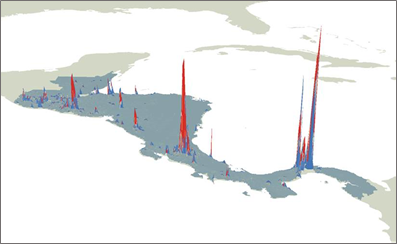
Many of the developing countries are exposed and highly vulnerable to adverse natural hazards. The economic impact of disasters is not evenly distributed among the population and increasingly, evidence suggests that the poorest are the most affected. Therefore, increased spatial granularity of Gross Domestic Product (GDP) data is important for more reliable and accurate disaster risk quantification. The novelty of this methodology relies on the characterization of urban areas and the control for individuals’ productivity using nighttime lights.
This innovative model produces gridded GDP maps at a 1km2 resolution as well as estimates of sub-national GDP values. In order to achieve scalability, we use globally available datasets such as LandScan population data set and nighttime lights data set from the National Oceanic and Atmospheric Administration (NOAA). This model opens the door to many applications in Disaster Risk Management including non-structural disaster loss estimations and for economic analysis of World Bank DRM projects.
Chair:
Oscar Ishizawa, Senior Disaster Risk Management Specialist
Presenter:
Paul Blanchard, Consultant
Discussant:
Alanna Simpson, Senior Disaster Risk Management Specialist